Here’s the Latest on the Spring Nor’easter Headed Our Way
Brace yourselves: The city could see 8 to 13 inches of snow — plus thunder and wind gusts — starting on Wednesday morning.
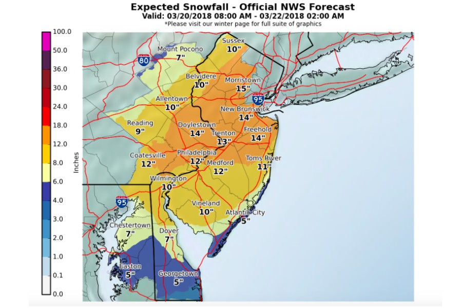
Image via the National Weather Service
This week’s unpredictable forecast has taken a turn for the worse.
A winter storm warning will go into effect for the Philadelphia area at 6 p.m. on Tuesday until 2 a.m. on Thursday. The National Weather Service says to expect mixed precipitation on Tuesday (likely light snow and sleet) and significant snowfall on Wednesday afternoon and evening.
This particular nor’easter (Winter Storm Toby, the fourth this month) is hard to predict, but forecasters say to expect between 8 to 13 inches of total snowfall in the city, as well as potential ice accumulations. Snow will be heavy on Wednesday, falling at a rate of 1 to 3 inches per hour in the afternoon. Thunder snow is possible during that time. The snow will taper off Wednesday evening.
The latest briefing for the latest coastal storm is available here: https://t.co/JiD09By93X Heavy snow, coastal flooding, and strong winds expected. #pawx #njwx #dewx #mdwx
— NWS Mount Holly (@NWS_MountHolly) March 20, 2018
The National Weather Service says to plan for limited visibility and slippery road conditions, especially during the Wednesday afternoon commute when the heaviest snowfall is expected. Read: You probably don’t want to go anywhere on Wednesday.
Widespread power outages are possible — with winds gusting 25 to 35 mph at times on Wednesday — so be sure to prepare for the worst (yet again).
We’ll continue to keep you updated as the winter storm approaches.
When it's the first day of Spring, but a Nor'easter is moving in…. pic.twitter.com/M9BkNaxCJr
— Good Morning America (@GMA) March 20, 2018