Snow and Even Colder Temps Are Headed Philly’s Way
Here’s what you need to know about the winter storm expected to start on Wednesday night.
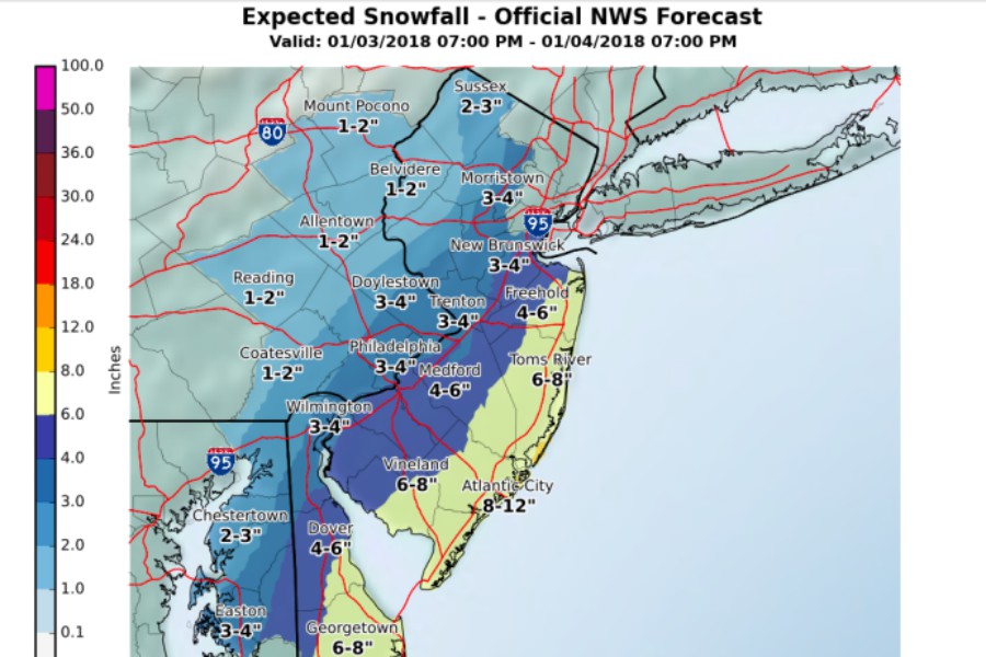
Projections for snowfall totals via the National Weather Service
Philly’s deep freeze is far from over.
In fact, it’s going to get worse before it gets better. Forecasters with the National Weather Service say we’re in for snow on Thursday – followed by a steep drop in temperatures. Here’s what you need to know.
A high-impact storm is expected to move up the East Coast starting Wednesday night through Thursday. Delaware and the New Jersey shore will see snow early Wednesday evening. The storm will move westward to the Philly region overnight.
Philly, is under a winter storm warning as of 4 p.m. on Wednesday, is expected to see 3 to 4 inches of snow throughout the day on Thursday. Snow in some areas (like the Shore, which is under a blizzard warning and expected to see 8 to 12 inches of snow) could be heavy at times – but depending on the movement of the storm, large differences in total snowfall over short distances could occur. Suburbs west of Philly will likely see 1 to 2 inches of snow.
Forecasters say we’re in for “a wickedly cold 48-hour period” between Thursday night and Saturday night, with high temperatures hovering around 15 degrees Fahrenheit on Friday and Saturday. Winds will increase as well on Thursday, with some gusts reaching 30 to 40 mph. Blowing and drifting snow will likely be a concern. The wind chill could remain below zero degrees all three days.
Some snow is in the forecast followed by extreme cold. Make sure you are prepared for the hazards of winter! For more tips visit https://t.co/EeIddX6cxf#PAwinter #PAwx pic.twitter.com/lm4lwLlClv
— Red Cross Philadelphia (@RedCrossPhilly) January 3, 2018
And now for a little good news! We’re in for above average temperatures next week (if you can make it through the weekend), according to the NWS. The organization claims that after the frigid temps, Monday and Tuesday could feel “like shorts and tees weather.”