Forecasters: Severe Thunderstorms Could Bring Lime-Sized Hail, Damaging Winds
The weather might seem perfect now, but a severe thunderstorm watch has been issued for the region through 11 p.m. Here's what you need to know.
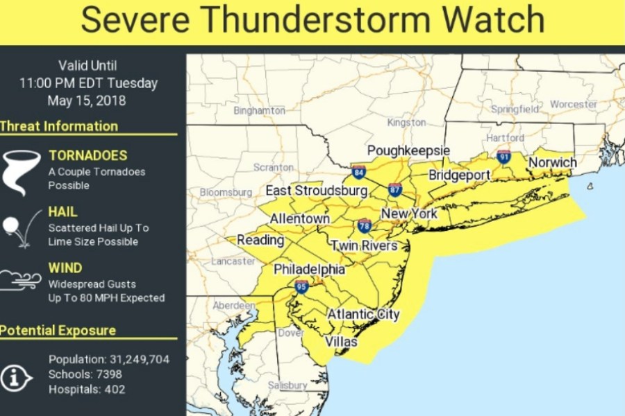
Image via the National Weather Service
The weather might seem positively blissful this Tuesday afternoon — but you’ll probably want to take cover in just a short while.
The National Weather Service has issued a severe thunderstorm watch for the area, in effect until 11 p.m. on Tuesday. Forecasters say serious storms expected to start after 5 p.m. could bring flash flooding, lime-sized hail (no, that’s not a typo for dime), and 80-mph wind gusts. Plus, a tornado or two is possible — though not especially likely.
Hail up to the size of limes are possible. That's not a typo!
— NWS Mount Holly (@NWS_MountHolly) May 15, 2018
Humidity and heat are expected to build throughout the evening as storms develop in New York and northern Pennsylvania before heading southeast, according to the NWS. There’s still some uncertainty regarding the storms, but the NWS says the primary/most probable risks in Philadelphia and the surrounding region include strong winds, large hail (up to 2 inches in diameter possible) and flash-flooding.
A severe thunderstorm watch means conditions are favorable for storms — so you should be on the lookout for threatening weather conditions. Be sure to check with the NWS for the latest updates.
Good afternoon! We are gearing up our severe weather operations for later this afternoon. Remain alert for severe thunderstorms, mainly between 4 PM and 11 PM especially for eastern PA and NJ. Have a trusted source for severe weather warnings later today. #pawx #njwx #dewx #mdwx pic.twitter.com/tCvuGXTnZX
— NWS Mount Holly (@NWS_MountHolly) May 15, 2018
In case you need to know what size 2" hail is, @NWSSPC has a handy conversion chart. Although "hen egg" is among the weirder entries. We'll just say egg-sized hail is possible. https://t.co/qjcXQfCn1M pic.twitter.com/vQW3rkxhIp
— Stephen Stirling (@SStirling) May 15, 2018