Bookmark This: The Bicycle Coalition of Greater Philadelphia Made a Papal Visit Bike Map
Papal Visit Bike Map
If you’ve been wondering how you’re going to get around the city when the Pope shows (haven’t we all been wondering that?), the Bicycle Coalition of Greater Philadelphia is here to make your life a little bit easier. They’ve created a Papal Visit bike map — which they will be updating, because information will surely change — that is sure to come in handy for those who get around the city on two wheels.
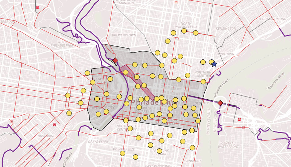
Right now, the map shows the traffic zone, the large chunk of the city from the Delaware River to West Philly where cars won’t be allowed to enter, but bikes will. It also highlights the Ben Franklin Parkway in red (if you’re actually trying to get somewhere, you’re probably going to want to avoid that area), along with the Ben Franklin Bridge — which, as of now, will be open to cyclists and pedestrians — and a possible Ben Franklin Bridge checkpoint. Plus, it shows circuit trails around the city and Indego stations, though BCGP says on their Facebook page, “Bike parking, the status of #RideIndego and the possible security checkpoint at the BF Bridge are all huge question marks.”
In a Facebook comment regarding the map, they also say, “We are in talks with the city about whether there will be roads for bike-use only.” The map is sure to go through some changes before the Pope’s arrival in September, but it’s worth bookmarking if you’re going to dare to brave the masses on two wheels come his arrival. You can check out the map below.
Like what you’re reading? Stay in touch with Be Well Philly—here’s how:
- Like Be Well Philly on Facebook
- Follow Be Well Philly on Twitter
- Follow Be Well Philly on Pinterest
- Get the Be Well Philly Newsletter