See 60 Years of Urban Change in Philadelphia With a Swipe of the Finger
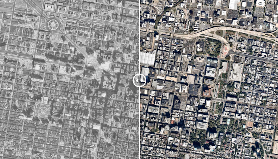
Image via University of Oklahoma’s Institute for Quality Communities | Click here for the slider.
This is almost too much fun. The Institute for Quality Communities at the University of Oklahoma just did you a solid today: they overlapped two photos of Center City Philadelphia, one from 1965 and another from 2014 and added a simple slider to let you see just how much the core of this city has changed over the last 60 years–it’s incredible.
The inclusion of the highway system probably provides the most stark examples between Philadelphia of yesteryear and today. However, you can’t help but notice the large white cluster in the center of the picture (slide it quickly, it’s mesmerizing) that is the Convention Center and The Gallery. You’ll also notice the shadows from the taller buildings built between then and now. Jeez, look at how much Society Hill has filled since the mid-1960’s.
Here are some details behind the project, which also gives the time-travelin’ treatment to cities like Boston and Pittsburgh:
60 years has made a big difference in the urban form of American cities. The most rapid change occurred during the mid-century urban renewal period that cleared large tracts of urban land for new highways, parking, and public facilities or housing projects. Fine-grained networks of streets and buildings on small lots were replaced with superblocks and megastructures. While the period did make way for impressive new projects in many cities, many of the scars are still unhealed.
• 60 Years of Urban Change: Northeast [Institute for Quality Communities–University of Oklahoma]