El Niño Behind Philly’s December Warm Snap Could Be Strongest in 65 Years
Sun via Shutterstock. Temperature chart via National Weather Service Mount Holly.
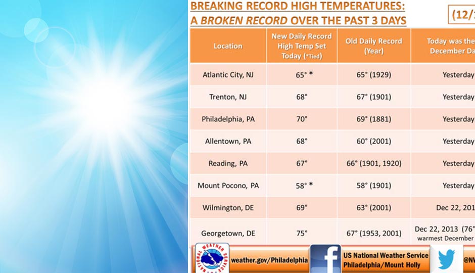
Did you enjoy Monday’s warm weather, when the temperature hit 70 degrees?
Get ready for a repeat on Christmas Day, when the thermometer is forecast to hit that mark again under sunny skies.
According to AccuWeather, our Christmas Day forecast high of 70 won’t be that much cooler than the temperature in antipodean Sydney, Australia, that day, where the forecast is for a stray afternoon thunderstorm or two and a high of 79.
But it’s the start of summer in Sydney. What’s our excuse?
Whatever it is, we can’t say for sure that it’s global warming, or climate change if you prefer.
The experts are quite sure El Niño has something to do with it, though, and that it’s not as strange as it may seem for us to have mild weather in December.
At least the expert we were able to reach this morning was. That would be Paul Pastelok, senior meteorologist with AccuWeather in State College.
“It’s hard to prove whether like this is due to climate change or not,” he said. “More research needs to be done and more data needs to be collected.”
Which may take a while, given our limited knowledge of El Niño, a meteorological phenomenon Peruvian fishermen recognized for centuries but which has become part of the popular consciousness in North America much more recently.
“What makes this El Niño so unusual is its strength,” Pastelok said. “This is the second strongest El Niño we have on record, and our records stretch back to 1950. We won’t know for sure until the numbers come in in February, but it could be the strongest.”
Pastelok said that there had been only five El Niños categorized as “very strong” since 1950, and that the weather patterns occurring now are fairly consistent with the last such strong El Nino in 1982-’83.
What we should be on the lookout for, he said, are strong storms in the middle of the winter. The El Nino of 1982-’83 had several of them affecting the Mid-Atlantic region.
Pastelok added, however, that mild December weather is actually not all that out of the ordinary. “We’ve seen weather like this outside of El Niño years,” he said. “The real winter influence doesn’t come until late January, February and March.” For instance, he noted, last winter also started out mild but ended up as one of the Northeast’s snowiest on record, with a succession of moderate-sized snowstorms coming one after another.
What is unusual, he said, has been the duration of the mild weather. “We’ve had strings of a few mild days in the past,” he said, but not almost 14 days of uninterrupted mild weather. And it’s not just here: Pastelok noted that temperatures in the Northern Plains are about 15 to 18 degrees above normal right now. The forecast high of 70 here on Christmas is 28 degrees above the historical average.
Exacerbating the trend is the lack of snow pack anywhere in the Northeast. “We don’t get a lot of snow in December in Philadelphia, but there’s no snow cover anywhere in the Northeast right now until you get to Maine. That’s why it keeps getting warmer — there’s no snow pack to reflect energy back into the atmosphere.”
Again, Pastelok said that there’s simply not enough data or research yet to pin this unusually lengthy December warm spell on climate change, and mild Decembers are not as big an exception as we think they might be. But he did have a bit more good news to add: Once winter does come, AccuWeather predicts it won’t be as brutal as last year’s was, the 1982-’83 parallel notwithstanding.
Follow Sandy Smith on Twitter.