UPDATE: National Weather Service Calling for Somewhat Less Snow
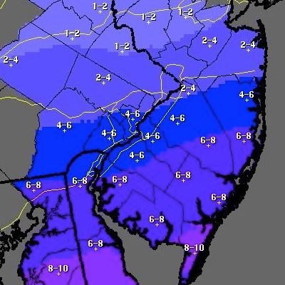
Updated snowfall map from National Weather Service.
UPDATE [10:55 p.m.]: National Weather Service has just released an updated snowfall map (left) which has pushed snowfall totals down somewhat. They’re now looking at 4-6 inches in the southern parts of the city and 2-4 inches in the Northeast and the northern suburbs (downgraded from 6-8 and 4-6, respectively):
“Trends continue to push amounts down across the north. Please visit our website to see the latest updates to our warnings and advisories. www.erh.noaa.gov/phi”
As we told you previously, the city’s snow emergency began at 10 p.m. (below), and the Philadelphia School District will be closed tomorrow.
ORIGINAL [6:20 p.m.]: 6ABC sums up the weather situation: “All city offices will be opening with a two hour delay on Monday. The School District of Philadelphia has not yet made a decision regarding schools but officials say an announcement will be made later Sunday. The Philadelphia Archdiocese has already announced that all of their schools will be closed Monday ahead of the storm.”
It’s just after 6 p.m., and according to the National Weather Service, we are now in the middle of winter storm warning. We’ve emphasized the fun parts:
…WINTER STORM WARNING REMAINS IN EFFECT UNTIL 1 PM EST MONDAY…
* LOCATIONS…THE INTERSTATE 95 CORRIDOR FROM THE PHILADELPHIA METRO AREA TO CENTRAL NEW JERSEY AND ACROSS TO COASTAL NORTHERN NEW JERSEY.
* HAZARD TYPES…MAINLY SNOW WITH SOME SLEET AND FREEZING RAIN POSSIBLE AT THE START THIS EVENING.
* ACCUMULATIONS…SNOW ACCUMULATION OF 4 TO 8 INCHES…ALONG WITH AROUND A TRACE OF ICE.
* TIMING…ANY RAIN THIS AFTERNOON WILL CHANGE TO A PERIOD OF SLEET OR FREEZING RAIN EARLY THIS EVENING THEN TO ALL SNOW BY LATE EVENING. SNOW WILL BE MODERATE TO HEAVY AT TIMES EARLY MONDAY MORNING BEFORE ENDING EARLY MONDAY AFTERNOON.
* WINDS…NORTH 5 TO 15 MPH WITH GUSTS UP TO 25 MPH.
* VISIBILITIES…BRIEFLY ONE QUARTER MILE OR LESS MONDAY MORNING.
* TEMPERATURES…PLUNGING FROM THE MID 30S LATE THIS AFTERNOON INTO THE UPPER TEENS TO AROUND 20 BY DAYBREAK MONDAY.
* IMPACTS…THE SNOW…SLEET AND FREEZING RAIN WILL CREATE HAZARDOUS DRIVING CONDITIONS TONIGHT. MONDAY MORNING`S COMMUTE WILL BE PARTICULARLY DIFFICULT.
* FOLLOWING THE STORM…NEAR RECORD COLD IS FORECAST LATE MONDAY NIGHT AS TEMPERATURES DROP TO BETWEEN ZERO AND 10 ABOVE.
PRECAUTIONARY/PREPAREDNESS ACTIONS…
THIS WINTER STORM WARNING MEANS THAT SIGNIFICANT AMOUNTS OF SNOW AND SLEET ARE EXPECTED. THIS WILL MAKE TRAVEL VERY HAZARDOUS OR IMPOSSIBLE.
The PPA is going to make everything OK:
In response to the the City’s Snow Emergency which is set to begin at 10 p.m. tonight, the Philadelphia Parking Authority (PPA) announced that beginning at 6 p.m. today – Sunday, March 2, 2014, the following PPA-owned-and-operated Center City garages will charge a flat 24-hour $5 parking rate until the end of the current snow emergency:
- AutoPark at JFK (16th & JFK)
- AutoPark at Independence Mall (5th & Market Streets)
- AutoPark at Jefferson (10th & Ludlow Streets)
- AutoPark at the Gallery (10th & Filbert Streets)
- Auto Park at Old City (2nd & Sansom Streets)
- 8th & Filbert Streets Garage
To receive the discounted $5 rate, customers must bring their ticket and pay at the PPA Management Office in each garage.
During this snow emergency, the PPA will enforce all snow emergency and safety violations. Meter and time limit violations will not be enforced until the snow emergency is lifted.
Additionally, the PPA announced that beginning at 10 PM tonight, it will begin ticketing and towing all vehicles that are parked illegally on snow emergency routes.
We’ll update this information tonight and early in the morning.