
Philly Could See Up to Two Feet of Snow This Weekend
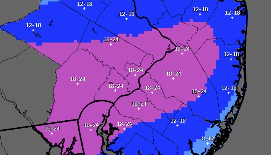
The National Weather Service’s latest snowfall prediction map as of 5 p.m. Friday.
According to the reliable folks at Phillywx.com Facebook Group, the storm looks like it’s going to hit Philadelphia a little earlier than we expected. Their latest estimate is between 5 and 8 p.m. in the city, and even earlier south of the city. NBC10 meteorologist Glenn “Hurricane” Schwartz is predicting it will start snowing around 6 or 7 p.m. Snow is already falling in the Washington, D.C., area. It’s coming, people.
As such, the conditions could start to get slippery on the roads earlier than many people expected. Drivers should use caution while traveling this evening (and all weekend). Drive slowly. Use your windshield wipers. The road might look wet, but it could just be ice.
Forecasts say Philadelphia will likely get between 18 and 24 inches of snow. Don’t be stupid. PennDOT Secretary Leslie Richards said yesterday that there were 552 crashes in snowy, icy or slushy road conditions last year traced to aggressive driving (speeding, careless lane changes, et cetera). Those crashes resulted in four deaths and 279 injuries. 511PA.com has traffic conditions for more than 3,000 miles of roadway in the state.
Driving behind a plow? #PennDOT says stay at least 6 car lengths behind & safely move over as far from center-line! pic.twitter.com/MwYdWAts8x
— TMA Bucks (@tmabucks) January 22, 2016
When driving behind a plow, keep at least six car lengths back. Stay away from the sides of plows as well. And never attempt to pass one on the road.
The Pennsylvania Turnpike will be lowering speed limits this weekend due to the storm. Starting tonight at midnight, speeds will be reduced to 45 mph between Breezewood Exit No. 161 to the Delaware River Bridge/New Jersey line. Speed limits will also be reduced to 45 mph between Mid County Exit No. 20 and Lehigh Valley Exit No. 56 on the Northeast Extension.
Follow @dhm on Twitter.