New Interactive Heat Map Shows Philly’s Most Popular Running and Biking Routes
Strava Labs Global Heatmap
Remember back in February when I told you about that map someone created logging popular running routes in Philly using data from the app RunKeeper? The new map I’m about to tell you about is similar, only this one’s clicky, so it’s way more fun.
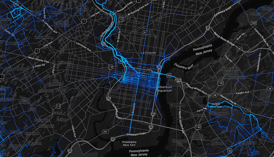
The latest iteration comes from fitness-tracker app Strava, which logs your runs and bike rides on your smartphone. The company took data from 77,688,848 rides and 19,660,163 runs logged with its software to create a heat maps showing where people run and bike the most. Like the last map, when you close in on Philly, this one shows a high concentration of activity on the Schuylkill Trail and the Ben Franklin Bridge—duh. But because this new map is interactive, and because we can filter for running routes, biking routes or both, we can get more out of it. Yay!
In the Strava map, we see that FDR Park is pretty popular among cyclists, and less so among runners. Cyclists also ride northeast, up Aramingo Avenue, and continue for nice long rides. This map also shows us the cluster of routes in Pennypack Park and the Wissahickon, which are obviously popular for both cyclists and runners.
And, we can go allllll the way out into the ‘burbs: Valley Forge registers nicely, as does the Radnor Trail, Ridley Creek State Park, and the Haverford College Nature Trail. Over in Jersey, cyclists seem to be all over the place, but runners cluster at the Cooper River Lake, and around Birchwood Lake near Medford Lakes.
Aside from being fun to look at, this map can give you lots of intel for new places to go for a run or ride. Happy clicking, friends.
Like what you’re reading? Stay in touch with Be Well Philly—here’s how:
- Like Be Well Philly on Facebook
- Follow Be Well Philly on Twitter
- Follow Be Well Philly on Pinterest
- Get the Be Well Philly Newsletter